![]()
A lightweight implementation of the geomorphon terrain form classification algorithm of Jasiewicz and Stepinski (2013) doi:10.1016/j.geomorph.2012.11.005 based largely on the ‘GRASS GIS’ ‘r.geomorphon’ module.
This implementation employs a novel algorithm written in C++ and ‘RcppParallel’.
For the sake of simplicity, some GRASS-specific implementation
details have not been added. See ?geomorphons for
details.
You can install {rgeomorphon} from CRAN:
install.packages("rgeomorphon")And you can install the development version from GitHub:
# install.packages("remotes")
remotes::install_github("brownag/rgeomorphon")This is a basic example using the classic R volcano
dataset and {terra} SpatRaster object as input.
volcano is a 10m by 10m grid of elevation values from
Maunga Whau in the Auckland volcanic field of New Zealand.
library(terra)
#> terra 1.8.56
library(rgeomorphon)

# PARAMETERS
SEARCH = 7       # outer search radius (cells)
SKIP = 0         # inner skip radius (cells)
FLAT = 1         # flat angle threshold (degrees)

# classic volcano elevation data
data("volcano", package = "datasets")

# construct and georeference a SpatRaster object
dem <- terra::rast(volcano)
terra::crs(dem) <- terra::crs("EPSG:2193")
terra::ext(dem) <- c(1756968, 1757578, 5917000, 5917870)
names(dem) <- "Elevation (meters)"

# calculate geomorphons "forms"
system.time({
    rg <- geomorphons(
        dem,
        search = SEARCH,
        skip = SKIP,
        flat = FLAT
    )
})
#>    user  system elapsed
#>   0.058   0.005   0.050

# inspect result
plot(c(dem, rg),
     plg = list(x = "bottomleft",
                bty = "o",
                bg = "white"))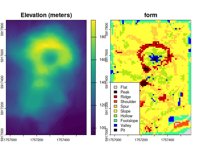
Now we will do a bathymetry example using the built in Salton Sea
dataset (salton).
See help("salton") for details.
library(terra)
library(rgeomorphon)

# PARAMETERS
SEARCH = 10      # outer search radius (cells)
SKIP = 3         # inner skip radius (cells)
FLAT = 0.1       # flat angle threshold (degrees)

# salton sea bathymetry sample data
data("salton", package = "rgeomorphon")

# construct and georeference a SpatRaster object
dem <- terra::rast(salton)
terra::crs(dem) <- attr(salton, "crs")
terra::ext(dem) <- attr(salton, "extent")
names(dem) <- "Elevation (feet)"

# calculate bathymorphons using 6-form system
system.time({
    rg <- geomorphons(
        dem,
        search = SEARCH,
        skip = SKIP,
        flat = FLAT,
        forms = "forms6"
    )
})
#>    user  system elapsed
#>   0.097   0.002   0.079

# inspect result
plot(c(dem, rg),
     plg = list(x = "bottomleft",
                bty = "o",
                bg = "white",
                cex = 0.85))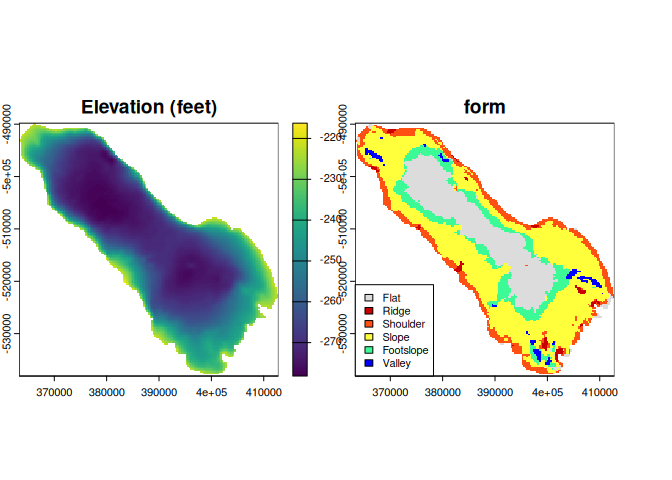
citation("rgeomorphon")
#> To cite package 'rgeomorphon' in publications use:
#>
#>   Brown A (2025). _rgeomorphon: A Lightweight Implementation of the
#>   'Geomorphon' Algorithm_. R package version 0.3.0,
#>   <https://github.com/brownag/rgeomorphon/>.
#>
#>   Jasiewicz J, Stepinski T (2013). "Geomorphons - a pattern recognition
#>   approach to classification and mapping of landforms."
#>   _Geomorphology_, *182*, 147-156. doi:10.1016/j.geomorph.2012.11.005
#>   <https://doi.org/10.1016/j.geomorph.2012.11.005>.
#>
#>   Jasiewicz J, Stepinski T, GRASS Development Team (2024). _Geographic
#>   Resources Analysis Support System (GRASS) Software, Version 8.3_.
#>   Open Source Geospatial Foundation, USA. r.geomorphon module,
#>   <https://grass.osgeo.org/grass-stable/manuals/r.geomorphon.html>.
#>
#> To see these entries in BibTeX format, use 'print(<citation>,
#> bibtex=TRUE)', 'toBibtex(.)', or set
#> 'options(citation.bibtex.max=999)'.